Flooding
3.5 Flood management strategy and plan
The strategy that runs through our flood control recommendations is to consider interventions in sequence. For each issue we question:
- First, is this flooding caused by another problem downstream and, if so, will downstream measures be sufficient to clear the issue?
- Second, what local measures could be taken to rectify the issue?
- Third, if steps one and two are not sufficient, what more could be done upstream to reduce the volume or the rate of flow so that flooding does not occur?
For every issue, our recommendations will begin at the downstream end and work progressively upstream.
Strategy for Flood Control centred on Bridge Street
To apply our flood management strategy for the Windrush Valley through Witney (where the key pinch point is the bridge in Bridge Street), our flood management plan considers:
- what interventions can be taken to clear blockages downstream of the bridge,
- what can be done at the bridge to maximise the flow capacity, and
- what interventions can be introduced upstream of the bridge to reduce the flow volume or to retain water that can subsequently be allowed to proceed at a reduced rate.

Intervention affecting all the Windrush valley
(This description is taken from the WODC December 2020 Flood Report)
Intervention 1
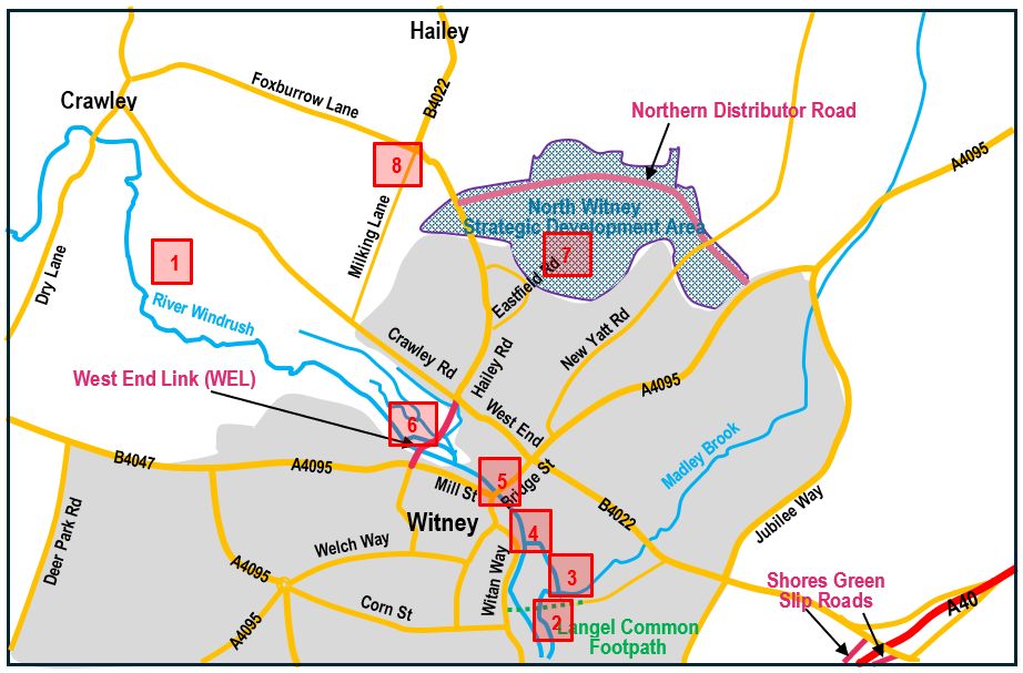
Description: Update the 2014 model with updated level information, especially downstream of the Aquarius Bridge through to the footpath at Langel Common. Include main tributaries through Witney.
WING understands that the Environment Agency is currently working on a complete review of its hydraulic model. The output from this would provide a better model on which to base flood predictions.
Interventions downstream of Bridge Street
(These descriptions are taken from the WODC December 2020 Flood Report)
Intervention 2
Description: Look at improving flows through Langel Common footpath to ensure flood plain connectivity is improved during all flood events.
A combination of raising the footpath level (to ensure the footpath does not flood) and increasing the number and size of the culverts through the footpath embankment (to stop water from backing up towards Bridge Street) would resolve this problem.
Intervention 3
Description: Investigate if the perimeter ditch of the Aquarius site can be modified/ diverted to increase flow capacity.
Intervention 4
Description: Investigate if the river could be modified to increase flow capacity during severe conditions, especially between New Bridge Street through to the footpath in Langel Common.
Interventions at Bridge Street
Intervention 5
Description: Dredge the river channel at Bridge Street bridge to maximise the flow capacity.
We understand that Witney Town Council has awarded a contract for this work to be done. Works are due to start in July 2024.
Interventions upstream of Bridge Street
Intervention 6
Description: Retain Windrush flood water in the flood plain by constructing the WEL on an earth dam. Water flow through the dam can be controlled by restricted openings in the dam.
This intervention is intended to allow the central basin area within Bridge Street, Mill Street, West End Link and West End to remain free from flooding. The flows entering this basin area are:
- River Windrush millstream through Woodford Mills
(Wier levels in the mill should be set to allow the maximum flow without overflowing the channel.) - River Windrush channel at the low point in the flood plain
(The river flow from the flood plain will be controlled by setting the width of the opening through the earth dam as defined by hydraulic modelling.) - Hailey Road drain
(Measures to limit this flow are set out in interventions 7 and 8.)
These combined entry-flows must not exceed the capacity that can exit the basin through Bridge Street bridge.
Intervention 7
Description: Attenuation ponds in North Witney housing development.
Intervention 8
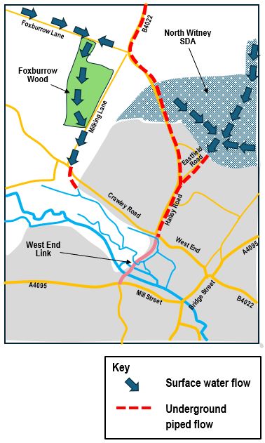
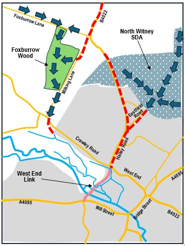
Description: Diversion of the surface water flow from Hailey village. Diverted route along Milking Lane and then in open streams and ponds through Foxburrow Wood to reach outfall into the Windrush in the flood plain upstream of the WEL.
Interventions 7 and 8 both deal with controlling the outfall from the Hailey Road drain into the flood risk basin above Bridge Street. Intervention measures are set out in the table below following the same strategy that we are using throughout this report.
Strategy for Flood Control centred on Hailey Road Drain
The 750mm diameter drain from the junction of Eastfield Road with Hailey Road down to the outfall into the basin area above Bridge Street is the focus for this table. Currently this length of piped drain becomes overloaded in periods of severe rainfall and overflows from the manholes onto the road surface. The outfall from the drain into the basin is also restricted because the basin is in flood. Consequently, more water backs up in the drain. The roundabout at the bottom of Hailey Road becomes flooded and impassable.


Interventions downstream of Hailey Road Drain
Intervention HR1
Description: Clear the obstructions and flooding issues downstream of Hailey Road to ensure there is a clear outfall into the basin.
This target should be achieved through completion of the Bridge Street interventions 1-6 as listed in the table above.
Interventions at Hailey Road Drain
Intervention HR2
Description: Consider measures to increase the capacity of the drain.
A complete reconstruction of this drain would be expensive and extremely disruptive. WING’s proposal is that this action could not be justified.
Interventions upstream of Hailey Road Drain
Intervention HR3
(linked to Bridge St Intervention No.7)
Description: Reduce the peak flow entering the Hailey Road drain from North Witney housing area by constructing attenuation ponds in the development area.
A series of small attenuation ponds is indicated in the developer’s proposals for North Witney housing. Although these may be adequate to limit the flow rate from the housing development into the existing piped drainage system and prevent an increase in flow, these proposals will not overcome the current flooding problems in the Hailey Road drain. Providing fewer, larger ponds to increase capacity would reduce flood risks for Witney.
The current drainage arrangement floods during severe weather events. An element of improvement is therefore essential.
Intervention HR4
(linked to Bridge St Intervention No.8)
Description: Reduce the total flow through the Hailey Road drain.
This target can be achieved by diverting the surface water drainage from Hailey village and redirecting it along Milking Lane and through Foxburrow Wood. The current piped drain that runs along the B4022 from Hailey Village to the Hailey Road Roundabout would be divided into two sections. The first section, from Hailey as far as Foxburrow Lane, would continue into Milking Lane, through Foxburrow Wood and then to an outfall in the Windrush flood plain upstream of the WEL. Within the Wood, new streams and ponds can be created to slow the flow rate, increase biodiversity, and improve the water quality using reed beds at the entrance to each pond. This is a project that the wood owners (Wychwood Forest Trust) are keen to deliver.
The second section of the drain would start downstream of Foxburrow Lane and join the Hailey Road Drain at the end of Eastfield Road.
Although this intervention at first appears to be minor, it will take out a considerable proportion of the flow that currently uses the Hailey Road drain and is an Important part of the overall strategy.